Anchor Out of Eelgrass
Anchor Out for Safety & Salmon on social media: Facebook | Instagram | Threads
What is eelgrass?
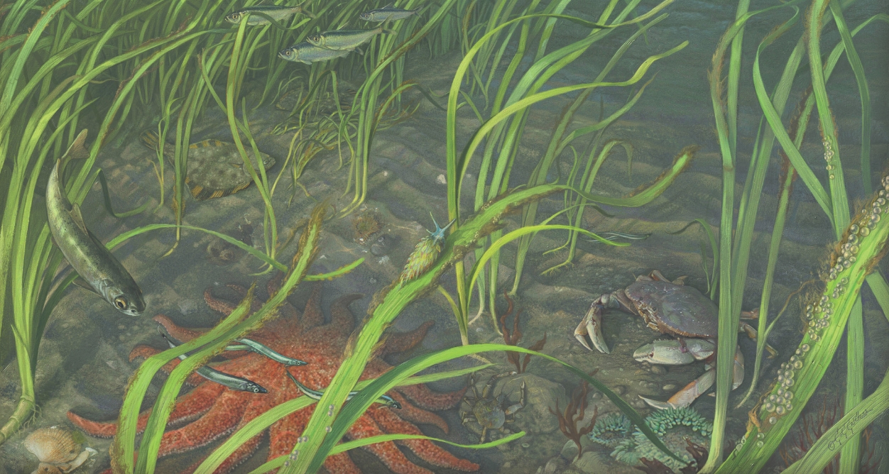
Eelgrass is a marine flowering plant, or seagrass, that grows near shore and forms large underwater meadows. These meadows are home to many marine creatures like Dungeness crabs, salmon, and herring. They also provide food, shelter, and nursery habitat for various species including birds, small invertebrates, and fish. Eelgrass meadows can help stabilize shorelines by buffering impacts from waves and reducing erosion.
Why anchor out of eelgrass?
Safer for you and better for the marine environment
 Anchoring in eelgrass can be risky for boaters because anchors do not hold well in the soft sand and mud where eelgrass grows. Instead of staying put, boats anchored in eelgrass are more likely to drift. We ask boaters to anchor out of eelgrass whenever possible to keep themselves, their boats, and other boaters safe.
Boat anchors, chains, and lines can cause damage to eelgrass beds as boats swing around, leaving scars. This can create bare patches in the eelgrass meadow that accumulate over time, increasing the impact to this sensitive habitat. This accumulated damage can have negative impacts on the marine life that relies on eelgrass.
Where does eelgrass grow?
(Almost) everywhere the light touches
 Eelgrass grows close to shore at depths where light can penetrate through the water.
The maximum depth at which eelgrass grows varies by region. In the Salish Sea (Puget Sound and Strait of Georgia), the deepest edge of an eelgrass meadow can be as shallow as 3 feet (1 meter) below the low tide line to as deep as 30 feet (10 meters) below the low tide line.
Below we include links to mapping resources with eelgrass locations in Washington and BC.
Voluntary no-anchor zones
A VOLUNTARY APPROACH TO EELGRASS PROTECTION
 A voluntary no-anchor zone is a protection area that indicates where eelgrass meadows are located and encourages boaters to anchor outside of this sensitive habitat. These zones are voluntary. Some voluntary no-anchor zones are marked by informational spar buoys and others are virtual and marked on navigation apps and onshore signs. Locations of Voluntary No-Anchor Zones in the Salish Sea are coming soon! You will be able to find locations on Active Captain, OpenCPN, the Boaters Guide App, and more coming soon!
Anchoring near eelgrass
Together, let's ensure our favorite spots remain havens for boaters and marine life by anchoring out of eelgrass!
Anchor outside of voluntary no-anchor zones when applicable
Anchor in at least 25 feet (8 meters) of water at low tide (Note: Depth recommendations can vary by region)
Or tie up at a marina or mooring buoy, when possible
Plan Ahead
Eelgrass Maps
When planning your next boating trip take the time to find out where eelgrass meadows are in Washington and British Columbia to help inform your anchorage site selection, visit:
- Friends of the San Juans Eelgrass Depth Map for the San Juan Islands: Indicates the depth to anchor beyond at destinations throughout the San Juan Islands.
- WA Dept. of Natural Resources Puget Sound Eelgrass Monitoring Data Viewer: Marks the location of eelgrass beds throughout Puget Sound.
- WA Dept. of Natural Resources Puget Sound Max. Depth of Eelgrass Beds Map: Indicates the depth to anchor beyond at destinations throughout Puget Sound.
- Marine Data Center’s Marine Ecosystem Map :Marks the location of eelgrass beds in British Columbia. To view this information, go to the layer list (top right corner of map), select Ecology > Marine Plants and Algae and turn on the Distribution of Eelgrass (2012-2014 SGI) and Distribution of Eelgrass (BC) layers.
Alternative Moorage
When feasible, consider moorage options in Washington and British Columbia to help avoid anchoring in sensitive eelgrass meadows, visit:
- British Columbia Marina and Harbours: Provides information on the location of and registration for marinas and Small Craft Harbours on the British Columbia coast and islands.
- WA State Parks Boat Moorage System: Provides information on how to identify and register for boat moorage through WA State Parks.
Salish Sea Partners in Eelgrass Protection
Anchor Out of Eelgrass is a collaborative effort by partners across Washington and British Columbia. For more information visit our partner webpages relating to eelgrass conservation efforts:

SeaChange Marine Conservation Society - No-Anchor Zones on Bowen Island and Gibsons Harbour
seagrass protection around the globe!
There are similar programs all over the globe to conserve seagrasses by informing best anchoring practices. Check out some examples below!
United States:
- Sailors for the Sea Tips for proper anchoring techniques to be mindful of sensitive habitat
- Tomales Bay Seagrass Protection | Greater Farallones National Marine Sanctuary
- Seagrass Safe Boating in Long Island Sound with the Fishers Island Seagrass Management Coalition
- Be Seagrass Safe in Florida
International
- Anchoring with Care in the UK from the Royal Yachting Association
- Save our Seabeds program in England
- Falmouth's new "Blue Meadows" buoys protecting seagrass fields
- MEDSEAGRASS program in Posidonia
- Study in Sardinia found an increase of up to 34% in anchoring damage to seagrasses following the tourist season
- Protecting seagrasses in the Gulf of Morbihan in France through boater education, check out their best practices video (video in French)
For more information contact: Dana Oster, Marine Program Manager | oster@nwstraits.org | 360-708-4146
 This project is also supported by funding from the Ecological Service's Program of the U.S. Fish and Wildlife Service.
Image credits: Sailboat at anchor (Optic Impulse), Eelgrass illustration (Larry Eifert), Rower (Jessica Owens), Eelgrass (Jim Ramaglia), No-anchor zone buoy (Jefferson MRC)
